Introduction

Coastal walkers may feel the busy resorts of the south coast are the last place they would venture for a day out. But there is one undeveloped and largely undiscovered section between Littlehampton and Bognor Regis which retains its bleak and beautiful natural landscape, and around which this short walk is based. It is perfect if you are in the area and want to get away from it all for a couple of hours.
The essentials
- Difficulty: Easy to moderate
- Length: About four miles, two to two and a half hours
- Recommended map: OS explorer series 121 – Arundel and Pulborough
- Details: Climping path description – PDF.
- Getting there: Parking is available at two points on this walk, Climping and Littlehampton, but the path description starts at Littlehampton. Walkers using public transport will find Littlehampton rail station very close to the start and bus information here.
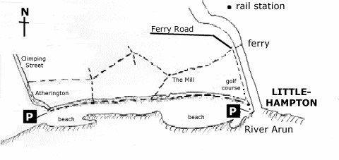
Sketch map

Route description
The walk starts from the West Beach pay and display car park which is right by the beach to the west of the mouth of the River Arun (grid reference TQ022018). Walk back along the car park approach road which is a single-track lane and is not too busy. You will pass the River Arun ferry and then the Arun Yacht Club on your right. Before long you will also see the large, white clubhouse of the Littlehampton Golf Club with its splendid verandah to your left. The walk follows the golf course boundaries for part of its length.
As the road becomes greener and overhung with trees the walker passes the 17th tee, again to the left, then the 16th green and the 16th tee (117 yards, par three, for the golfers in the audience) and a water hazard. Just as the road widens and becomes busier take a public footpath to your left marked with a fingerpost. The footpath runs between wooden fences for a brief spell before emerging on the golf course. Go through a gate marked with a “Beware Golf Course” sign – heeding the warning – and walk onto the course across a grassy embankment between two tees. Ignore the routes to left and right, which are for golfers teeing off, and continue straight ahead where, after a few yards, the path plunges into trees to follow the course boundary.
Now follow the narrow, tree-lined path along the course’s edge for some distance. This section has a tendency to be muddy and overgrown so walking shoes or boots and trousers may be advisable. As you walk you will see the greens and tees of the golf course begin to give way to a coastal landscape with dunes visible on the horizon providing a real contrast of scenery. Continue along the golf course boundary until you reach a kissing gate where the path forks just by the 12th tee. For an escape route back to the beach take the left hand fork.
This walk continues along the right-hand fork past the buildings of The Mill. It follows another pleasant, wooded section of path which may also be a little muddy underfoot. Follow it for some distance as it twists and turns through the woods until, after a series of sharp dog-legs, it emerges at a stile and a finger-post. Over the stile the path continues across a field for a short distance before coming to another junction marked by finger posts. At this crossroads take the left-hand path and do not go straight across, if you cross a stone slab serving as a footbridge you have gone too far.
Now the path continues through fields until it meets the road leading to Climping Gap. Cross a footbridge by a hedgerow and continue straight on towards the trees and rooves ahead. Go straight over a four-way footpath junction with fingerposts for toilets and the Climping Gap car park. But anyone wanting to cut off the short road section should turn left for a direct path to the beach and then left again once there for Littlehampton. Other walkers should continue straight on until a short plunge into trees gives way to a metalled road opposite a hotel entrance.
Turn left onto the road and walk towards the sea along Climping Street. You will pass ruined walls to your left and a disabled access path to your right before passing through the hamlet of Atherington. When you reach the end turn right into the car park for the toilets or continue through the gap into the sea wall for the last undeveloped stretch of coast between Brighton and Bognor Regis (grid reference TQ008007). It is also a nature reserve and a Site of Special Scientific Interest (SSSI). There is an information board here describing the area’s history and wildlife. Walkers wanting to extend their walk can turn right to follow the beach to Middleton-on-Sea, Felpham and the outskirts of Bognor. But be prepared to retrace your steps as there is no convenient circular route to return by.
Turn left along the beach and stick close to the sea wall to avoid the worst of the shingle on this bleak and lovely section of coastline. Littlehampton Pier, which can now be seen in the distance, marks the end of the walk. Keep to the right of the concrete coastal defences and follow the raised area of shingle along the middle of the beach for the easiest walking. Keep the scrub and bushes to your left – and the sea to your right! Soon to the left a footpath sign marks the path which follows the golf course boundary and provides an escape route back to Littlehampton and West Beach car park for anyone who is already sick of the shingle. There is another information board here about the nature reserve.
Walkers continuing along the beach are now approaching the West Beach nature reserve. Sand dunes begin to rise on the left, covered in marram grass, and this sensitive area is now fenced off for its own protection. Walkers should keep the fence to their left and keep following the path of the coast. When you reach Littlehampton Pier, as the dunes rise to dominate the landscape, turn left and, following its course inland, you arrive back at the West Beach car park.